YELLOWSTONE - LAKE AREA

MAINLAND ADVENTURE 
Sept 2013

Sunday Sept 1
            Hoping for an early start we were up and ready to go at 8am when Erica called – she would meet us for dinner. 
            As we headed back down toward the lake area, we stopped off to see Mud Volcano.  Actually the road traffic was at a standstill before we got there because a herd of buffalo was crossing.  When we were able to pull over and walk to the mud feature we were treated with seeing the buffalo cross over a ridge and into the little valley where we were standing.  It was a thrill, like being in the past and observing them as they once were (and are again in this magical land).

Busy grazing 

 Two have just thundered down the hill, 
note big guy still at top ready to make his descent

 Mom and calf

 We were mesmerized as the whole herd passed before us into this valley


 This feature at Mud Volcano was interesting 
but the critters are hard to beat 

Another mud volcano with the sun hitting it


A sign on Fishing Bridge says “no fishing” because only grizzlies are allowed to fish for cutthroat trout here, especially during their spawning season.  The museum at Fishing Bridge Visitor Center is a lovely old building with all its taxidermy birds and great info. I was shocked when I walked in and saw two types of swans.  I had seen swans along one of the rivers and dismissed them – couldn’t be – so I missed the chance to stop and really look at them.  The arctic swan is huge and the trumpeter swan even bigger.  The relief map of Yellowstone Lake that our geologists friends worked on was here too.


Lake map  
YS Lake is 137 sq mi (see west thumb at far left - a good sized lake on its own)

            Next stop was a short hike to Storm Point on the lake.  The destination was a rocky outcropping  that housed marmots . The path was through meadow and forest and past a large pond.  When I saw it was adjacent to Pelican valley I was on the lookout for pelicans -  I had learned to suspend rational thinking and it paid off - we did see a pelican.

 This area is at the northern edge of Lake Yellowstone
The circular pond at top of map is Indian Pond


 Indian Pond

 Pelican on Indian Pond (near Pelican Valley)

 A peek at the lake from the forest, 
steam vents are at Steamboat Point across the way

Gil is checking out "steamboat" 
Storm Point beyond him 


We saw butterflies, dragonflies, and red squirrels
no marmots (maybe already hibernating) and no bears 

            Erica had also suggested Sylvan Lake and the pass near the park’s East entrance before leaving the area.  Nice picnic at the lake.  

Sylvan Lake 


Sylvan pass
Evidence here reminded us that this park was first visited on 
horseback and/or horse and carriage - Yikes!

           We stopped back in at Fishing Bridge museum to figure out which birds we had seen.  After puzzling two rangers we moved on. We had a nice drive to the Old Faithful area where we would spend two nights.  One more waterfall just before reaching geiser land.

Kepler Cascades with Mr. Gil

YELLOWSTONE - CANYON

MAINLAND - YELLOWSTONE NATIONAL PARK
Friday - Saturday Aug 30/31

            Our next accommodations were at Canyon Lodge so we entered Yellowstone through the south entrance along the Lewis River and saw Lewis Falls, 30’ high. 

Lewis falls

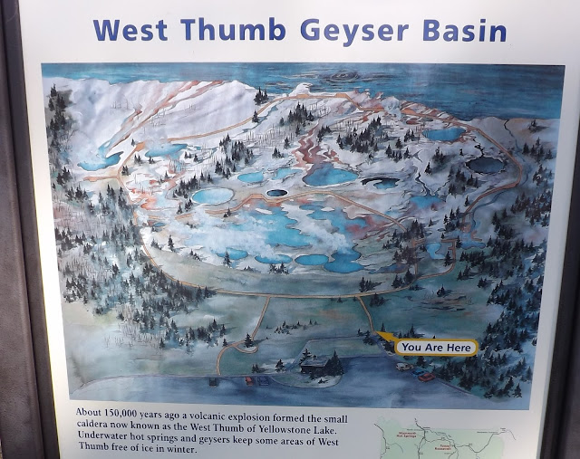
We were going right on past the lake area for now, all along the West Thumb – Yellowstone Lake is huge.  We were catching on; this region is laced with rivers and lakes – lots and lots of water.  As we drove the perimeter, we watched the lake go from placid to choppy and then wave action as the wind picked up.  We went to the Grant Village Visitor Center and then took the boardwalk in the West Thumb geyser basin getting our first look at the beautiful hot sulphuric water pools. 

Geyser Basin 


One hot spring with the West Thumb of Yellowstone Lake in background
Phenomenal scale here

The boardwalk makes it safe for the people and to preserve the delicate biosphere

The colors were exquisite; due to living organisms that are as yet little understood


We also got our first close looks at bison, two herds in the road and two along side. 

 It used to be bears that stopped traffic in Yellowstone
the wild bison are making a bit of a comeback - about 4000


This became a common site - but never less exciting
These are not being raised for food like in Hanalei,
The park is theirs


We checked into our frontier cabin at Canyon Lodge.  It was very cute, all wood with Yellowstone maps and trout all over the bedspread; tiny shower and bath, sink in the bedroom. Routine for nat'l parks, no tvs, no phones, no internet (except pay as you go and only from one location in each area.)  Luckily, sometimes our droids worked but even that became unimportant in a few days and I left mine off unless we were doing separate things. 
Once settled, we went out to see the canyon and check out the waterfalls on the north rim.  We’ve seen the purple Grand Canyon, the red & green Waimea Canyon at home, Black Canyon in western Colorado, and now the yellow canyon of the Yellowstone River.  The evening light was beautiful.


Many lookouts along the canyon give different views 


The lower falls - a 308' drop

        
Saturday
            We jammed out to see the canyon from the south rim in morning light.  

This is the classic view

A popular spot for photos, lots of exchanging - great times


If the sheer dimensions of Yellowstone aren’t staggering enough, there are the details that give a glimmer of a time bigger than humans reckon with. 

 How does it stay suspended?

Sheer determination


We checked out the Canyon Visitor Center while waiting to meet up with our pal Erica.  A beautiful two story center, this is where our education really began about the gigantic volcano that Yellowstone Park sits on.  When it blew last, 640,000 years ago, the ash covered about half of what is now the US


Yellowstone caldera

It sits over magma that is relatively close the surface. The steam vents, hot springs, mudpots, and geysers are all various conditions of water heated by magma.  The volcanic bulge that Yellowstone represents makes the area 2,000 feet higher than surrounding lands!  She’s gonna blow one of these days. 

Yellowstone is on a hot spot much like the one that formed the Hawaiian Islands.  What is wild is that the N. American plate is moving southwest (opposite of the Pacific plate moving northwest).

Hotspots
           

            Erica was back from lunch and on duty; she has been a Yellowstone ranger for 25 years (except when she was at Teton or Sequoia).  When the summer season is over, she runs a winter yurt camp for hardy folks to snowshoe and cross-country ski near Canyon.  I took a photo of a mural showing the canyon in winter.

Erica Hutchings, Ranger
her parents live next door to us in Kauai so we see her now and then
Fun to see her in her element

Mural at Canyon Visitor Center
Yellowstone Canyon in winter, frozen falls at back

            Erica sent us on a hike to Cascade Lake. We crossed the Yellowstone River en route to the trail head.  We would have some time with her on Sunday and Monday.

Looking up river on the Yellowstone 

Down river before it enters the lake

The 5 mile round trip hike was through both forest and meadow where we saw bison, a red tail hawk, and osprey.  I even thought I saw a bear.

A couple bison munching in one of the meadows we walked through

We watched this red-tail hawk catch a field mouse 

The Osprey are finally making a comeback after the debacle of the US use of DDT 
We watched a pair circling each other


Cascade Lake

Sharon's bear

            We were very aware if dead trees due to previous fires in Yellowstone rather than due ti beetle kill.  The new growth was very apparent.           


 New growth

Old charred guys

            We had to move on and return to the lake area for our frontier cabin at Lake Lodge.  It was even cuter than the one at Canyon and we loved the Lodge.  We had some dinner then got a couple beers (I switched to Moose Drool port and Gil stayed with his Snake River lager).  We curled up by the big fireplace with some dice but couldn’t concentrate.  We ended up meeting two geologists – the ones that had mapped Yellowstone Lake!  What a trip.


Gil and Lucille (fits right in doesn't she?) 

Yellowstone Lake across from the Lodge

Goodnight!


MAINLAND - TETONS

NORTH TO WYOMING
Aug 28 - 30, 2013

            On Wednesday we locked out at the cabin and drove to Granby for gas; lunch at Steamboat Springs, CO and got to Rock Springs, Wyoming at dinner time and for the night.  We named the truck Lucille in route, just like BB King’s guitar.
           Baggs, WY, just over the border is testing for methane in the ground – Carbon County having produced petroleum products for many decades including propane currently.  More exciting, we saw our first Pronghorns – mostly grazing.

 Wyoming road - mountains finally in sight

Our first pronghorns - pretty far away so they are blurry
Always a sentry (on right)


Thurs Aug 29
             We stopped in Jackson for gas and silicone at the auto parts store – Gil was determined to get rid of the wind noise on my side.  There was both rain and hail while we gassed up. (FYI:  Jackson is the town, any area completely surrounded by mountains was called a hole by the trappers, ie, Jackson Hole).

            Fascinated by the size of the elk refuge north of Jackson we drove up there and visited the Art Museum – fabulous.  The elk arrive after the first snow, as many as 19,000 winter here.

The museum is high up on the hillside
the elk refuge is the valley floor behind sign 

Some of the many outdoor bronzes 

                           Fabulous paintings, drawings, Indian works and sculpture 
“Familiar Roles”  by Nancy Glazier


Kids room - this got my imagination going!


We got our first glimpse of Grand Teton before arriving at Teton Village
and then saw it for the next 24 hours as we traveled along the base

Teton Village is a ski resort and we saw a tram shown on the map.  Chris at our hotel suggested we take the gondola up to a restaurant for happy hour.  As we approached the tram area and paid our fare we saw the busyness of a pretty mountain community.  The attendant on the tram said might see a bear cub so we should look for it on the way up.  We didn’t see that but saw the restaurant go by under us and realized we were on the wrong vehicle.  He said we could walk to it from the top, about 40 minutes.  I don’t think so. 

Kinda fun, we hadn't been on a tram since Switzerland

 Teton Village below


The restaurant - with deck in front - where we were supposed to be going!

On the way back down we did see the young black bear on the mountain and a bald eagle in a tree-top!  We took the proper, smaller gondola up to The Deck and had a spectacular view of the village below while we ate.  (The restaurant is reservation only, $155 per person with wine pairings - next time?)

The Deck was awsome - mostly locals that come for happy hour
no charge on the Bridger gondola


The Valley below 

Yum - black sesame edamame and tempura portobellos
Snake River lager (the snake river runs north all the way through the Tetons)

            Back at the hotel I struggled to get online – no go.  Little did we know it would be difficult the whole trip!


Friday Aug 30
We shook up our protein and hit the road.  Teton National Park is fabulous.  First stop was the Moose Visitor Center for an informative ranger talk at the 3D map and then on to Jenny Lake.  Beautiful.  Goodbye to Grand Teton, south Teton, Middle Teton, Owen and Moran – as good as I had imagined since I was a kid and knew would see them one day. 

  Tetons:  Grand: 13,770', Middle 12,804, South 12,514


Jenny Lake
Mt. Owen 12, 928' 


 Jackson Lake - Elk Island in center


We were impressed with the size of Jackson Lake as we navigated past until we were nearly out of the park.  Goodbye Tetons.